Ordnance Survey
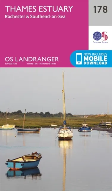
Ordnance Survey Thames Estuary, Rochester & Southend-On-Sea
Best price incl. delivery
£11.79
£7.80 + £3.99 delivery
Prices range from £7.80 to £12.34 across 5 stores
Millets.co.uk+£3.99 delivery
5 stores
BrandOrdnance Survey
EAN9780319262764
Compare prices
About this product
The OS Landranger Map series covers Great Britain with 204 detailed maps, perfect for day trips and short breaks.Each map provides all the information you need to get to know your local area and includes places of interest, tourist information, picnic areas and camp sites, plus Rights of Way information for England and Wales.OS Landranger now includes a digital version of the paper map, accessed through the OS smartphone app, OS Maps.
Price History (Last 30 Days)
Lowest Price Ever
£11.79
Millets.co.uk · 10 May 2026
Highest Price
£16.33
Whsmith.co.uk · 28 Apr 2026
Recent Price Changes
Ordnancesurvey.co.uk·2 May
£11.99→£12.99↑£1.00
Frequently Asked Questions
What is the cheapest price for Ordnance Survey Thames Estuary, Rochester & Southend-On-Sea?
The cheapest price for Ordnance Survey Thames Estuary, Rochester & Southend-On-Sea is £11.79 (including delivery) from Millets.co.uk.
How many stores sell Ordnance Survey Thames Estuary, Rochester & Southend-On-Sea?
We compare prices from 5 different UK stores to help you find the best deal for Ordnance Survey Thames Estuary, Rochester & Southend-On-Sea.
Does Ordnance Survey Thames Estuary, Rochester & Southend-On-Sea come with free delivery?
Yes! 2 of our partner stores offer free delivery on Ordnance Survey Thames Estuary, Rochester & Southend-On-Sea.
What is the price range for Ordnance Survey Thames Estuary, Rochester & Southend-On-Sea?
Prices for Ordnance Survey Thames Estuary, Rochester & Southend-On-Sea range from £7.80 to £12.34 across different retailers.
Independent price comparison·Prices updated regularly
CodeLand may earn commission from purchases made through our links, at no extra cost to you.